
The Taming of San Pedro Creek
Once untouched, the San Pedro Creek was an abundant and lush landscape, ripe with its natural flora and fauna.
Audio Tour
Once untouched, the San Pedro Creek was an abundant and lush landscape, ripe with its natural flora and fauna. That changed dramatically as the town grew in the mid-to-late 1800s and houses and businesses began to crop up, taking the place of the natural habitat.
Periodic and devastating floods caused the need for a solution, especially after 1917, when a narrow underground tunnel meant to allow the creek to pass under the Missouri, Kansas & Texas railyard (also known as the M-K-T or the Katy) made things worse.
Subsequent widening of the creek helped, as did stone and concrete walls to prevent collapse. However, the construction completely changed the aesthetic of the once-plentiful creek, reducing it to a concrete drainage ditch. By 1951, the city established the San Antonio River Channel Improvement Project, a monumental effort that addressed 31 miles of waterway improvements throughout the city.
Further work to alter the creek occurred throughout the late 1900s, including a project to widen, deepen, and straighten the channel in the 1970s and a flood bypass tunnel completed in 1991. These efforts allowed for the creation of the San Pedro Creek Culture Park where the waters of San Pedro Creek flow in beauty once again.
Audio Guía
En su estado natural, el Arroyo San Pedro era un paisaje abundante y exuberante, maduro con su flora y fauna natural. Eso cambió dramáticamente conforme la ciudad crecía a mediados de 1800 y las casas y negocios empezaron a multiplicarse, sustituyendo el hábitat natural.
Las inundaciones periódicas y devastadoras crearon la necesidad de una solución, especialmente después de 1917, cuando se construyó un estrecho túnel para que el arroyo pasara por debajo de la playa de maniobras Missouri, Kansas & Texas (también conocido como el M-K-T o el Katy), que empeoró las cosas.
Para prevenir derrumbes, se ensanchó el arroyo y se construyeron paredes de piedra y concreto. Sin embargo, la construcción cambió totalmente la estética del arroyo, una vez abundante, quedó reducido a una zanja de concreto para drenaje. En 1951, la ciudad estableció el Proyecto de Mejoras del Canal del Río San Antonio, un esfuerzo monumental que cubrió 31 millas de mejoras a la vía fluvial en toda la ciudad.
El trabajo adicional para alterar el arroyo ocurrió a finales del siglo 20, incluyendo un proyecto para hacerlo más ancho, más profundo, y para enderezarlo en los años 70; y además un túnel de alivio para las inundaciones, terminado en 1991. Estos trabajos fueron la base para la creación del Parque Cultural del Arroyo San Pedro, lugar donde las aguas del Arroyo San Pedro fluyen con toda su belleza otra vez.
Image Gallery
English
Español
-
The original blessing of San Antonio–its abundant waters–would eventually have to be controlled to allow the city to grow and flourish.
The pristine and lush natural setting of the primordial creek, with its riparian abundance of flora and fauna, would change dramatically as the town grew in the mid-to-late 1800s. Though garden plots and grazing land along the creek and nearby streets would give way to building sites for houses and businesses, the creek itself remained largely unchanged until the early 1900s. But the periodic floods that damaged adjacent properties and claimed lives worsened in 1917 when the creek was channeled into an overly narrow underground culvert downstream from here to facilitate construction of the terminal for the Missouri, Kansas & Texas Railroad (known as the M-K-T or the Katy). City leaders later made plans to widen the creek in order to speed the passage of flood water. Depression-era programs funded work to straighten the creek and line its walls with stone and concrete to prevent collapse. The course of San Pedro Creek that had emerged over thousands of years, was gradually transformed from a natural waterway into a concrete drainage ditch, a process that continued in the 1940s when the channel was re-directed to accommodate highway construction.
By 1951 ongoing urban development and subsequent worsening flooding led to adoption of the San Antonio River Channel Improvement Project. This monumental effort would address 31 miles of waterway improvements throughout the city, including along San Pedro Creek. Work to widen, deepen, and straighten the creek south of downtown was finished in the mid1970s, and the San Pedro Creek flood bypass tunnel, designed to protect the downtown area, was completed in 1991. Completion of this tunnel made it possible to establish a world-class linear culture park and restore the onetime splendor of the creek’s aquatic environment. The waters of San Pedro Creek flow in beauty once again.
Audio Tour
Once untouched, the San Pedro Creek was an abundant and lush landscape, ripe with its natural flora and fauna. That changed dramatically as the town grew in the mid-to-late 1800s and houses and businesses began to crop up, taking the place of the natural habitat. Periodic and devastating floods caused the need for a solution, especially after 1917, when a narrow underground tunnel meant to allow the creek to pass under the Missouri, Kansas & Texas railyard (also known as the M-K-T or the Katy) made things worse. Subsequent widening of the creek helped, as did stone and concrete walls to prevent collapse. However, the construction completely changed the aesthetic of the once-plentiful creek, reducing it to a concrete drainage ditch. By 1951, the city established the San Antonio River Channel Improvement Project, a monumental effort that addressed 31 miles of waterway improvements throughout the city. Further work to alter the creek occurred throughout the late 1900s, including a project to widen, deepen, and straighten the channel in the 1970s and a flood bypass tunnel completed in 1991. These efforts allowed for the creation of the San Pedro Creek Culture Park where the waters of San Pedro Creek flow in beauty once again.
Courtesy: Light Collection, University of Texas at San Antonio Libraries Special Collections and Hearst Corporation. 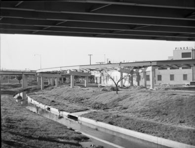
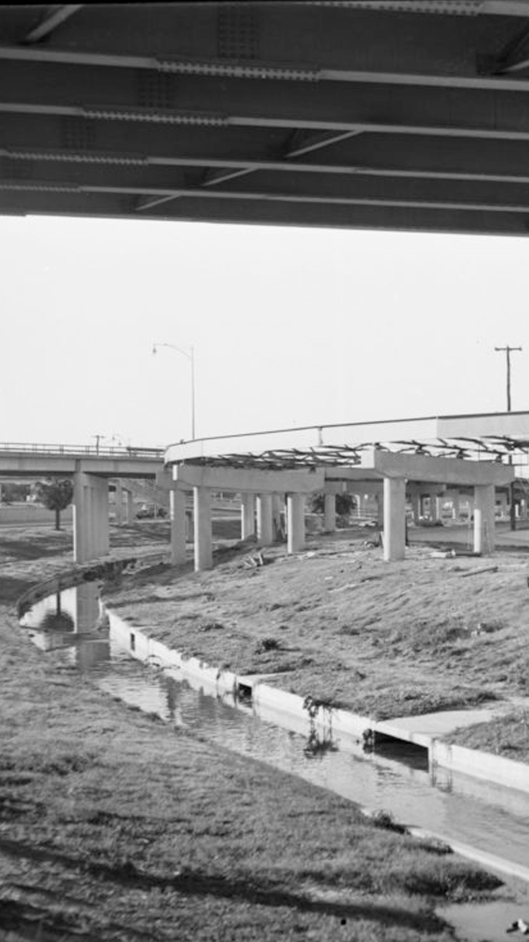
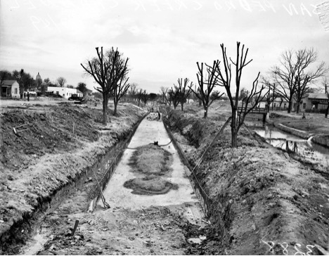
Courtesy: Express-News Collection, University of Texas at San Antonio Libraries Special Collections and Hearst Corporation. San Pedro Creek was reconfigured to accommodate construction of the city’s expressway system in 1949. This work involved filling in the natural channel (above) and building a new concrete-lined channel (below).
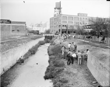
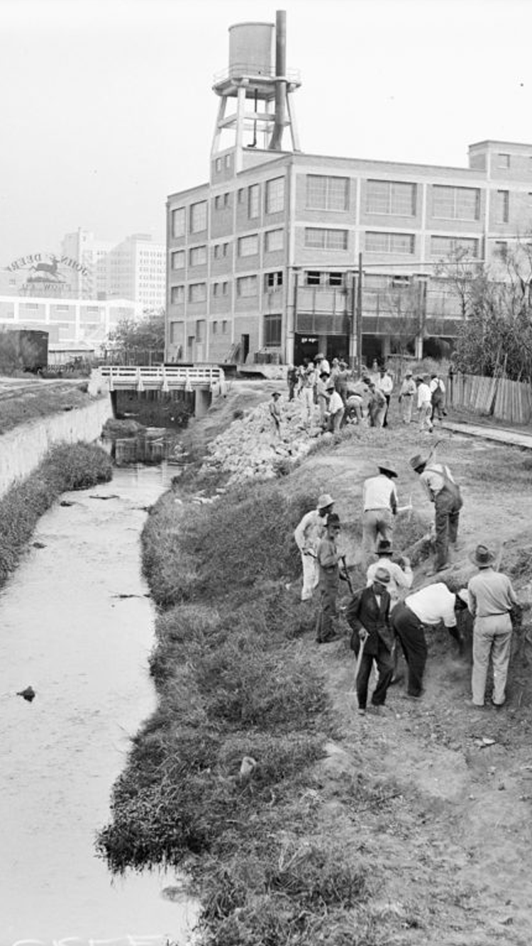
Courtesy: Light Collection, University of Texas at San Antonio Libraries Special Collections and Hearst Corporation. The Taming of San Pedro Creek Relief workers were employed during the Depression to build concrete walls along San Pedro Creek to contain flood waters. Laborers constructed walls downstream from this site near today’s César Chávez Boulevard.

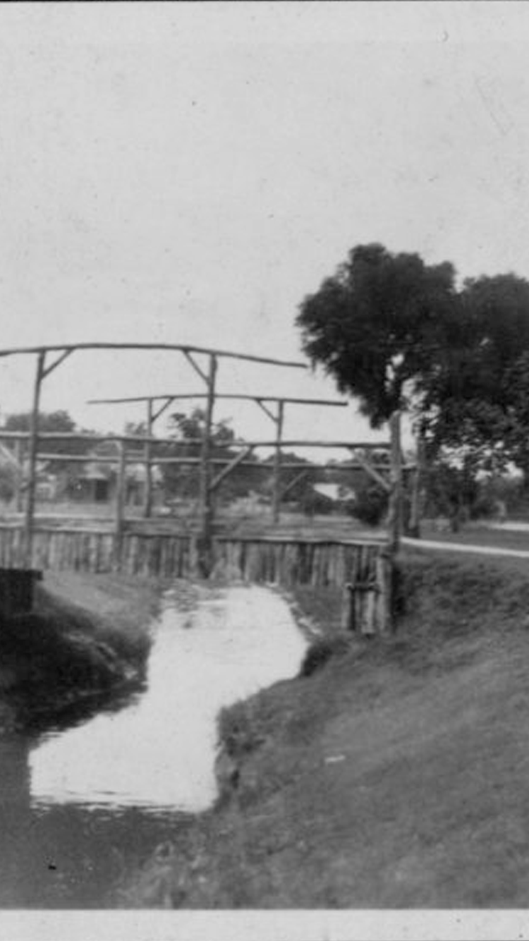
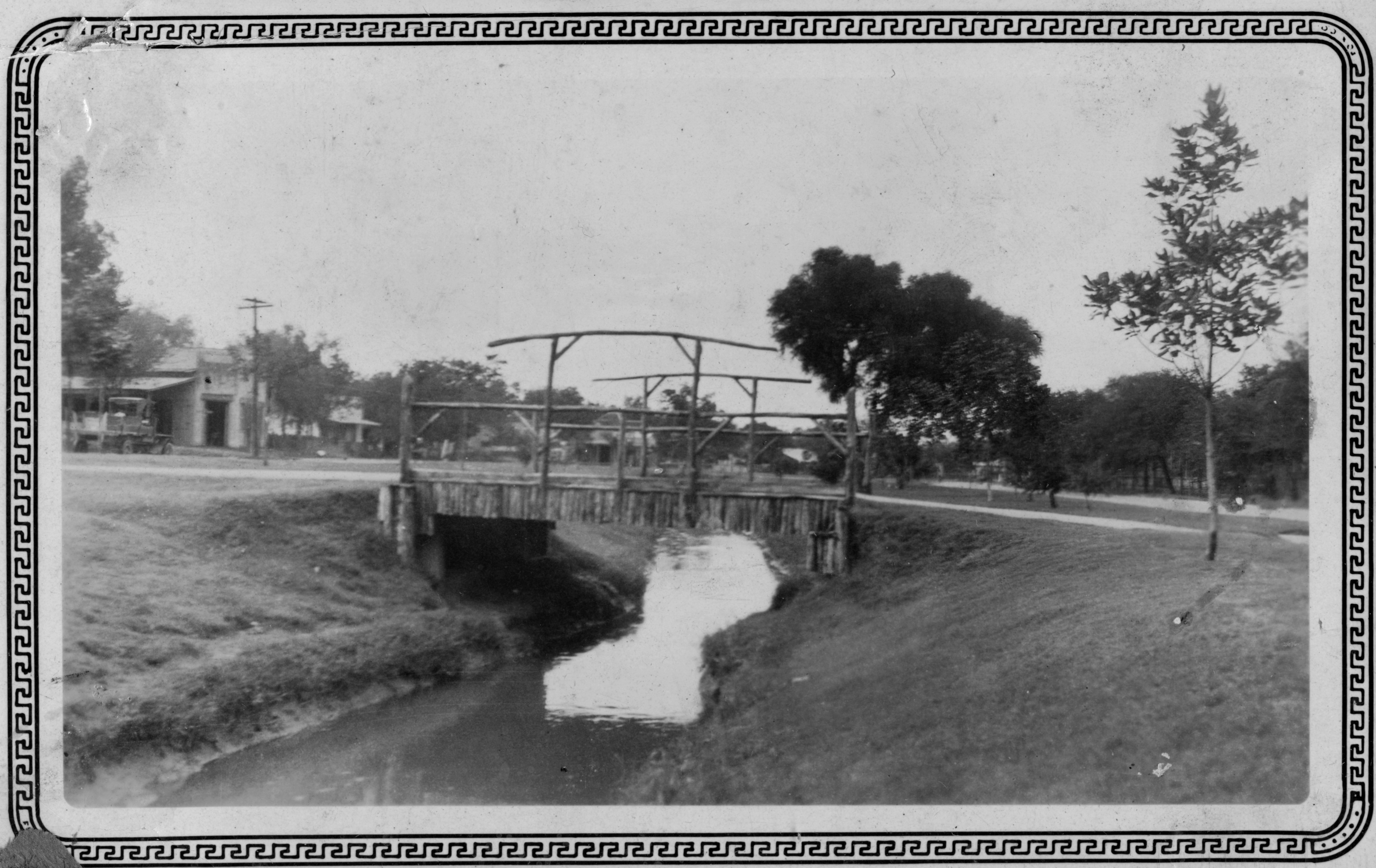
Courtesy: University of Texas at San Antonio Libraries Special Collections. Bridges for pedestrians and vehicles connected neighborhoods on either side of San Pedro Creek as pictured here in the late 1920s.
-
La abundante agua de San Antonio, su bendición original, eventualmente tendría que ser controlada para facilitar que la ciudad creciera y floreciera.
El ambiente natural del riachuelo original, con su abundancia de flora y fauna en su ribera, cambiaría drásticamente a medida que la ciudad crecía a mediados a finales del siglo XIX. Aunque los terrenos y pastizales a lo largo del arroyo y otras calles cedieron paso a la construcción de casas y negocios, el arroyo en sí se mantuvo prácticamente sin cambios hasta principios del siglo XX. Pero las inundaciones periódicas empeoraron en 1917, cuando el arroyo fue desviado hacia un drenaje aguas abajo, demasiado estrecho, para facilitar la construcción de la playa de maniobras del ferrocarril Missouri, Kansas y Texas (conocido como MKT o Katy). Posteriormente, los líderes de la ciudad hicieron planes para ensanchar el arroyo a fin de aumentar el volumen de agua que fluía por su cauce. Durante la Gran Depresión se crearon programas para financiar los trabajos de enderezar el arroyo y revestir sus paredes con piedra y hormigón para evitar su colapso. El cauce del Arroyo San Pedro, que se formó durante miles de años, se transformó gradualmente de una vía fluvial natural a una zanja de concreto, un proceso que continuó en la década de 1940 cuando el canal fue redirigido para ceder espacio a la construcción de carreteras.
En 1951 el constante desarrollo urbano y las inundaciones periódicas dieron paso al Proyecto de Mejoras al Canal del Río San Antonio. Este esfuerzo monumental comprendería 31 millas de mejoras y ampliaciones a las vías fluviales de toda la ciudad, incluso a lo largo del Arroyo San Pedro. El trabajo para hacer el arroyo más ancho, más profundo y más recto, al sur del centro de la ciudad se terminó a mediados de la década de 1970; y el túnel para desviar los excesos de agua del Arroyo San Pedro, diseñado para proteger el área del centro, se finalizó en 1991. La terminación de este túnel hizo posible crear un parque cultural, lineal y de clase mundial y así restaurar el esplendor acuático que en otras épocas tuvo el arroyo. Ahora, las aguas fluyen una vez más por un hermoso Arroyo San Pedro.
Audio Guía
En su estado natural, el Arroyo San Pedro era un paisaje abundante y exuberante, maduro con su flora y fauna natural. Eso cambió dramáticamente conforme la ciudad crecía a mediados de 1800 y las casas y negocios empezaron a multiplicarse, sustituyendo el hábitat natural. Las inundaciones periódicas y devastadoras crearon la necesidad de una solución, especialmente después de 1917, cuando se construyó un estrecho túnel para que el arroyo pasara por debajo de la playa de maniobras Missouri, Kansas & Texas (también conocido como el M-K-T o el Katy), que empeoró las cosas. Para prevenir derrumbes, se ensanchó el arroyo y se construyeron paredes de piedra y concreto. Sin embargo, la construcción cambió totalmente la estética del arroyo, una vez abundante, quedó reducido a una zanja de concreto para drenaje. En 1951, la ciudad estableció el Proyecto de Mejoras del Canal del Río San Antonio, un esfuerzo monumental que cubrió 31 millas de mejoras a la vía fluvial en toda la ciudad. El trabajo adicional para alterar el arroyo ocurrió a finales del siglo 20, incluyendo un proyecto para hacerlo más ancho, más profundo, y para enderezarlo en los años 70; y además un túnel de alivio para las inundaciones, terminado en 1991. Estos trabajos fueron la base para la creación del Parque Cultural del Arroyo San Pedro, lugar donde las aguas del Arroyo San Pedro fluyen con toda su belleza otra vez.Courtesy: Light Collection, University of Texas at San Antonio Libraries Special Collections and Hearst Corporation. Courtesy: Express-News Collection, University of Texas at San Antonio Libraries Special Collections and Hearst Corporation. El Arroyo San Pedro se reconfiguró en 1949 para dejar espacio para la construcción del sistema de autopistas de la ciudad. Este trabajo implicó cerrar el canal natural (arriba) y construir un nuevo canal revestido de concreto (abajo).
Courtesy: Light Collection, University of Texas at San Antonio Libraries Special Collections and Hearst Corporation. Durante la Gran Depresión, se emplearon trabajadores adicionales para construir muros de concreto a lo largo del Arroyo San Pedro para contener las aguas en su cauce; se construyeron muros aguas abajo de este sitio, cerca del Bulevar César Chávez de hoy.
Courtesy: University of Texas at San Antonio Libraries Special Collections. Puentes para peatones y vehículos conectaron los vecindarios a ambos lados del Arroyo San Pedro como se muestra aquí a fines de la década de 1920.


Creek Quiz
What happened to the local residents during the Siege of Béxar and the Battle of the Alamo?
Most residents became refugees and fled the settlement.
