facebook pixel San Pedro and the Labor de Abajo - San Pedro Creek Culture Park Skip to content

San Pedro and the Labor de Abajo

The land south of the Presidio San Antonio de Béxar along San Pedro Creek was valued by early residents for its fertile soil and access to abundant water.
Image Gallery

San Pedro and the Labor de Abajo

San Pedro y la Labor de Abajo

English
Español
  • The land south of the Presidio San Antonio de Béxar along San Pedro Creek was valued by early residents for its fertile soil and access to abundant water. The irrigated farmland, which became known as the Labores de Abajo (lower farmlands), was used for communal farming by presidial soldiers in the 1720s and by settlers from the Canary Islands (Isleños) following their arrival in 1731. These residents were followed by newly arrived immigrants from Mexico, Europe, and the United States who also relied on the creek to water their gardens and livestock. San Pedro Creek continued to play an important role in the community, and the Labores de Abajo remained a source of agricultural goods until the mid-1800s. As the town grew, fertile fields along the creek disappeared with the construction of houses, businesses, and factories. Streets, railroads, and, later, highways completed this transformation, and by the early 1900s, San Pedro Creek had lost its importance, and the Labores de Abajo lay beneath the modern city.

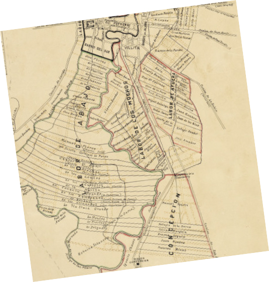
    Photo: Fritz Flohr Reynolds; Courtesy: Creative Commons (CC BY-SA 3.0).

    The Labor de Abajo is outlined on this map drawn by former city engineer and surveyor, John D. Rullmann. Based on Rullmann’s extensive research, the map depicts San Antonio de Bexar as it appeared in 1837. San Pedro Creek, the San Antonio River, and acequias (irrigation ditches) that provided water to the fields are illustrated.


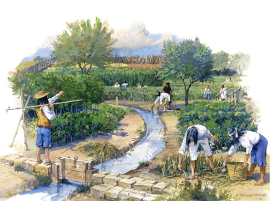
    Water from the San Pedro Creek and San Antonio River was channeled through acequias (irrigation ditches) to fields in the Labor de Abajo where crops were grown and livestock was raised.

  • El suelo al sur del Presidio de San Antonio de Béxar a lo largo de San Pedro Creek fue valorado por los primeros residentes por su tierra fértil y acceso a abundante agua. Las tierras de cultivo irrigadas, que se conocieron como Labores de Abajo, fueron utilizadas para la agricultura comunal por soldados del presidio en la década de 1720 y por colonos de las Islas Canarias (Isleños) luego de su llegada en 1731. A estos residentes les siguieron los inmigrantes recién llegados de México, Europa y Estados Unidos, quienes también dependían del arroyo para regar sus huertos y dar agua a su ganado. San Pedro Creek siguió desempeñando una función importante en la comunidad, y Labores de Abajo siguió siendo una fuente de productos agrícolas hasta mediados del siglo XIX. A medida que el pueblo creció, los campos fértiles a lo largo del arroyo desaparecieron con la construcción de viviendas, negocios y fábricas. Las calles, los ferrocarriles y, más tarde, las carreteras completaron esta transformación y, a principios del siglo XX, el San Pedro Creek había perdido su importancia y las Labores de Abajo yacían debajo de la ciudad moderna.

    Photo: Fritz Flohr Reynolds; Courtesy: Creative Commons (CC BY-SA 3.0).

    La Labor de Abajo se describe en este mapa dibujado por el ex ingeniero y agrimensor de la ciudad, John D. Rullmann. Basado en la extensa investigación de Rullmann, el mapa muestra a San Antonio de Bexar tal como se veía en 1837. Se ilustran el San Pedro Creek, el San Antonio River y las acequias (zanjas de riego) que proporcionaban agua a los campos.


    El agua del San Pedro Creek y el San Antonio River se canalizó a través de acequias (zanjas de riego) a campos en Labor de Abajo donde se cultivaban los campos y se criaba ganado.

Get the latest on the San Pedro Creek Culture Park
Sign up for email updates
SIGN UP
I understand that subscribing to the email list means that I agree to receive emails, including updates from San Pedro Creek Culture Park. I can update my preferences and unsubscribe at any time.
close-link