Out of its origins in Nueva España, independent Mexico, and Texas, an American city took shape.
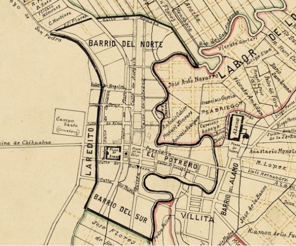
The community grew slowly in the years after its founding in 1718. In the earliest years of this community of New Spain, military and civilian residents intermingled, and there was no organized civilian settlement. By royal decree, municipal government was formalized in 1731 upon the arrival of fifteen families from the Canary Islands. Because land west of San Pedro Creek lacked irrigation and was often at risk from ongoing Indian attacks, the colonists were settled near the presidio that stood on the creek’s east bank. In July 1732 Captain Juan Antonio Pérez de Almazán laid out the new civilian villa that included a central plaza, the ejido (a town common), and land for collective grazing and farming (the labores). Town and outlying lots were granted to the Isleños (Canary Islander families). As the town grew, it was organized into barrios that would shape and imprint the city’s future–the Barrio del Sur, Barrio del Norte, Barrio del Alamo, La Villita, El Portrero, and the Barrio de Laredo, each represented by its own commissioner. The Barrio del Norte included land lying between the creek and river stretching from the town’s plazas to just north of this site. An acequia (irrigation channel) dug from San Pedro Springs south to near the creek’s confluence with the San Antonio River was completed in 1734 to provide water to homes and farms in the Barrio del Norte. Because of its access to abundant water and proximity to the plazas that were the center of community life, the Barrio del Norte developed into a thriving neighborhood where members of diverse ethnic groups lived and worked side by side.

San Antonio was organized into governmental units known as barrios as illustrated on John Rullman’s map of the city as it was in 1837. Rullman based his map, published in 1912, on extensive historical research.
De sus orígenes en Nueva España, México independiente y Texas, una ciudad estadounidense tomó su forma actual.
La comunidad creció lentamente en los años posteriores a su fundación en 1718. En los primeros años de esta comunidad de Nueva España, los residentes militares y civiles se entremezclaron, y no hubo un asentamiento civil organizado. Por decreto real, el gobierno municipal se formalizó en 1731 con la llegada de quince familias de las Islas Canarias. Debido a que las tierras al oeste del Arroyo San Pedro carecían de riego y estaban en riesgo por los ataques de los nativos, los colonos se establecieron cerca del presidio construido en la orilla este del arroyo. En julio de 1732 el capitán Juan Antonio Pérez de Almazán trazó la nueva villa civil que incluía una plaza central, el ejido (un centro comunitario) y tierras para el pastoreo colectivo y agricultura (las labores). Algunos lotes de la ciudad y de la periferia fueron otorgados a los Isleños (familias de las Islas Canarias). A medida que la ciudad creció, se organizó en barrios que conformarían y dejarían huella en el futuro de la ciudad: Barrio del Sur, Barrio del Norte, Barrio del Álamo, La Villita, El Portrero (Potrero) y el Barrio de Laredo, cada uno representado por su propio comisionado. El Barrio del Norte comprendía los terrenos que se encuentran entre el arroyo y el río, extendiéndose desde las plazas de la ciudad hasta justo el norte de este sitio. Una acequia (canal de riego) excavada desde los Manantiales San Pedro hacia el sur hasta cerca de la confluencia del arroyo con el Río San Antonio se completó en 1734 para suministrar agua a las casas y granjas del Barrio del Norte. Debido a su acceso a agua abundante y a su proximidad a las plazas que eran el centro de la vida comunitaria, el Barrio del Norte se convirtió en un vecindario próspero donde miembros de diferentes grupos étnicos vivían y trabajaban lado a lado.

San Antonio se organizó en unidades gubernamentales conocidas como barrios, como se ilustra en el mapa de la ciudad de John Rullman, como era en 1837. Rullman basó su mapa, publicado en 1912, después de extensa investigación histórica.


